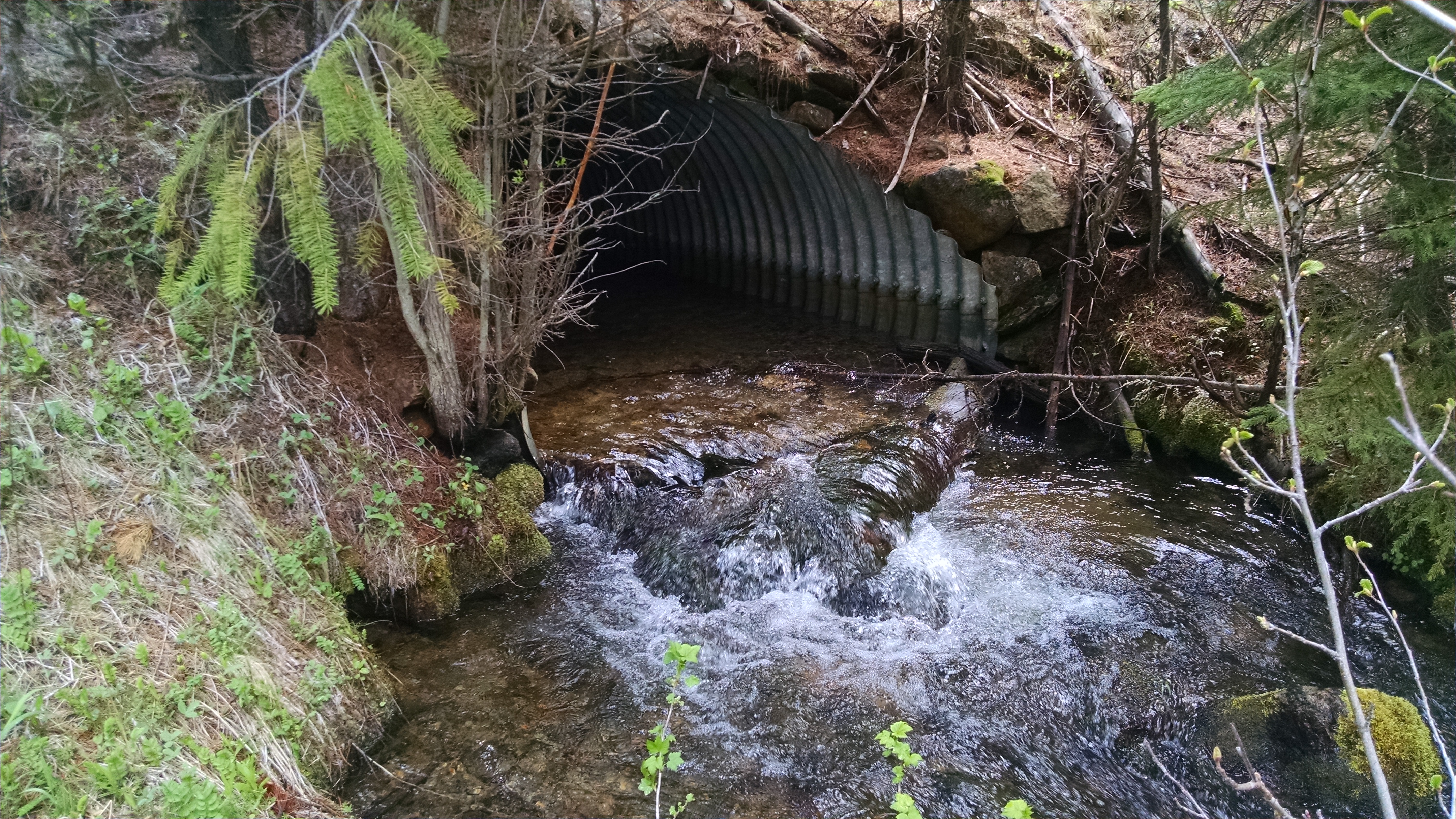
This project will improve fish passage and riverine connectivity in the Granite Creek Watershed which is a high priority watershed located in Eastern Oregon. The project targets 3 specific sites on Boundary and Corral Creeks, which are located east of the rural town of Granite in the Wallowa-Whitman National Forest. These streams are critical spawning and rearing habitat for Endangered Species Act designated threatened Bull Trout. Three old culverts, located on two perennially flowing creeks, are undersized and poorly aligned relative to the road. The erosion, sedimentation, and passage barriers produced by the road and culvert placements cause habitat quality reduction and species fragmentation. The outcome is deterioration of the aquatic ecosystem in the Bull Run sub-watershed.
This project will improve fish passage and riverine connectivity in the Granite Creek Watershed which is a high priority watershed located in Eastern Oregon. The project targets 3 specific sites on Boundary and Corral Creeks, which are located east of the rural town of Granite in the Wallowa-Whitman National Forest. These streams are critical spawning and rearing habitat for Endangered Species Act designated threatened Bull Trout. Three old culverts, located on two perennially flowing creeks, are undersized and poorly aligned relative to the road. The erosion, sedimentation, and passage barriers produced by the road and culvert placements cause habitat quality reduction and species fragmentation. The outcome is deterioration of the aquatic ecosystem in the Bull Run sub-watershed. By replacing these ineffective culverts, this project will improve fish passage, open approximately 10 miles of viable habitat, enhance watershed health, and increase awareness of the species: Columbia River Basin Bull Trout (Salvelinus confluentus), interior Redband Trout (Oncorhynchus mykiss gairdneri), Middle Columbia River steelhead (O. mykiss) and Chinook salmon (O. tshawytscha). The culverts are passage barriers which fragment fish populations in the streams or eliminate fish from some reaches altogether. Installation of wider, open- bottom style culverts will promote a continuous streambed with appropriate water flow. The new culverts will accommodate 100-year flow volumes while concurrently preventing constriction of the 2-year flow in the selected sites. In addition, approximately 3 miles of road will be re-routed to reduce direct sediment outwash into the streams. The project may also re-construct two enhancement culverts on small, intermittent tributaries of Boundary Creek. Correcting the flow of the Boundary and Corral Creeks will improve western native trout populations currently impacted by the barriers in the creek systems and strengthen population integrity in the Granite Creek Watershed, a crucial high- elevation habitat that will become increasingly important for fish populations as temperatures continue to rise.
Specific Project Accomplishments:
1. The project will restore fish accessibility to cold headwaters throughout 9.2 miles in an area which provides multiple lifecycle habitats including spawning and rearing for endangered trout species.
2. The source of sedimentation will be minimized by realigning roads that were originally located without adequate consideration for stream impacts.
Human Interest/Community Benefit: The John Day River, as one of the longest undammed rivers in the United States, provides essential habitat for a variety of anadromous fish and native federally listed endangered or threatened species of trout. Historic land use of the Granite Creek watershed and Bull Run sub-watershed created many long-lasting environmental problems. Initially, excessive beaver trapping altered the shade-producing vegetation of the riparian zones. With the discovery of gold in 1861 in Granite Creek, came the relentless search for the precious commodity and the imminent, structural decline of the river channel. The forest was heavily logged for timber. As roads were hastily constructed in the area, the culverts were placed irrespective of the environmental impacts, resulting in partial barriers to migrating fish and utilization voids in places that once supported spawning. Today, the system is constrained by two definitive manmade characteristics: 1) Passage barriers caused by culverts which are incompatible with fish migration and spawning and, 2) Sediment inputs originating at roads that are closely aligned with the stream flow. In one instance the road arcs around the culvert, submitting sediment from both sides. Just downstream of Boundary Creek, Bull Run Creek has been 303(d) listed by the Oregon Department of Environmental Quality due to high levels of sediment and elevated summer stream temperatures, further emphasizing the critical need to open the access to the higher elevation, cold water habitats.
This project will emphasize the importance of collaboration through partnerships with two high schools - the local Ukiah and Prairie City high schools- and a collaborative Student Day of teaching citizen science-style experiential stream monitoring will be presented. Local students will learn about the importance of restoration projects and will receive hands-on practice in field science, and monitoring water temperature, sediment levels and flow. This aspect of the project will increase community awareness of fish habitat, the life cycles of western native trout, and the effectiveness of regional efforts focus on restoring trout populations. In conjunction with content supported by the science teachers from the two schools, the Student Day will meet and exceed Oregon Department of Education Content Standards for a high school science class. This opportunity will give students the chance to practice science in the field under the guidance of working practitioners and to observe the importance of restoration projects such as this. Using the streams as a classroom, the Student Day will emphasize the importance of habitat rehabilitation for fish which rely on connectivity in their environment in order to complete their life cycle and increase population numbers. The project will also be featured on the North Fork John Day Watershed Council website and Facebook page, reaching a broad audience through social media and online presence.
Project Timeline: The designs were completed as of April 2017. In early 2018, fish capture and exclusion will take place at the building sites prior to the removal of the old culverts. In the summer in-stream work window of the same year, the new, open-bottomed culverts will be implemented and the road relocation will occur.
Monitoring and evaluation: For three years following construction of the culverts and road re-alignment, the success and impact of the project will be monitored by a Project Coordinator from the North Fork John Day Watershed Council. The three sites will be monitored for flow, turbidity, and other water quality metrics two times per year during the monitoring time period. Redd count monitoring will take place annually and presence/absence will be established by fish surveys. In addition, the Wallowa Whitman National Forest will conduct annual structure inspections to determine design effectiveness. Photo-points will be established prior to work and will be repeated annually for three years. The first year of monitoring will include short courses taught to Ukiah and Prairie City high school students on stream health and restoration as well as the impacts of environmental degradation on sensitive species of fish (i.e. Bull Trout, interior Redband Trout, Chinook, and steelhead). The students will then assist the Project Coordinator in monitoring water temperature, sediment levels, and stream discharge.
Economic Calculator results:
Jobs: 8.6
Total Sales: US$792,765 Value Added: US$496,994 Income: US$360,016
Partners: North Fork John Day Watershed Council, Wallowa Whitman National Forest, the Confederated Tribes Umatilla Indian Reservation, U.S. Fish & Wildlife Service, Oregon Watershed Enhancement Board.
